Satellite-based drill rig navigation cuts costs Sandvik TIM3D: Pacesetter in usability, accuracy and speed
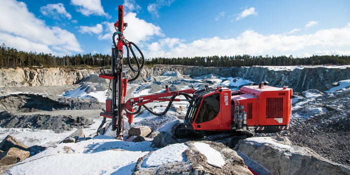
At Bauma 2013, Sandvik is releasing the 2nd version of their advanced 3D navigation system for Sandvik DX series surface top hammer drills. Among the new features in TIM3D V2 are a completely new type of user interface, wireless data transfer, and improved compatibility with external systems. Based on satellite systems, the modern TIM3D V2 navigation significantly improves drilling accuracy, efficiency and productivity in quarrying, road construction and open pit mining applications.

Sandvik TIM3D V2 is a drill rig navigation system consisting of four essential operations: Rig navigation, feed alignment, drilling and reporting.
The TIM3D navigation system improves hole quality and hole position accuracy. It produces parallel holes and keeps hole spacing and bottom levels accurate, translating into better fragmentation and decreased amount of boulders and fines. This results in increased efficiency further in the production process, both in crushing and loading and hauling. The system also removes the need for surveying and any hole marking, thereby minimizing the risk of errors and significantly speeding up drilling.
Based on a multi-satellite RTK GNSS navigation, the TIM3D is compatible with GPS and GLONASS satellite systems. Navigation uses drilling plans made either with standard office programs or with the system itself. Wireless data transfer, a new feature available to V2, improves user comfort and process speed. Transferring drill plan data via a USB memory is also possible. Drill plans are in IREDES standard format, containing the start and end coordinates of the target holes in three dimensions. Local base station, or a VRS correction, keeps navigation accuracy within 5 centimeters and thereby the total system accuracy within 10 centimeters.
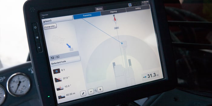
Usability of the system in V2 is greatly improved by an ultra-fast computer and the look and feel of the new interface. All buttons and icons are designed for smooth functionality and great performance. Drilling process is made simple. The system compares the position of the drill bit with the planned hole position and guides the operator to move the bit to the correct starting point of the chosen hole. V2 also introduces a possibility to indicate the direction of rows in drill plan generation by setting the drill bit to any given point in the first row. During drilling, the operator can follow the penetration rate and drilled depth, distance to target, number of required holes and current feed alignment. Furthermore, drilling stops automatically at the target depth. The system also shows the status of the holes with colour codes in the tramming view.

TIM3D allows the operator to deviate from the drill plan if needed, for example due to infeasibility of the planned starting point. Despite the modification, the hole bottom remains as planned: TIM3D system automatically calculates a new course based on the actual starting point of the hole. It is also possible to change the starting and ending points of the hole but still keep the direction, inclination and bottom level of the hole. In V2, it is also possible to use GPS mode to drill without a pre-set plan. In that case the system continuously shows hole depth, target depth and the level of bit at a given moment.
The drilling data – drilled holes and their actual parameters - are stored in the system memory. Data of drilled holes can thus be retrieved any time and drilling continued even despite the plan having been already started and closed. The drilling data can be exported to external programs as IREDES xml file. A report is created of each finished drill plan, including information on position and depth of the drilled holes, and drilling time. In addition, the system produces a hole report even when GPS mode is being used.
The TIM3D V2 navigation system with new outlook is available for Sandvik DX series surface top hammer drill rigs. The new outlook will be introduced to Sandvik DPi surface top hammer rigs at the beginning of 2014.
See it in action at: http://www.youtube.com/watch?v=xoOdf5U68fs
For further information, please contact:
Satu Rämö
Global Marketing Communication Manager
Sandvik Construction
Office Phone: +358 205 44 151
Mobile Phone: +358 40 537 4020
E-mail: satu.ramo@sandvik.com